
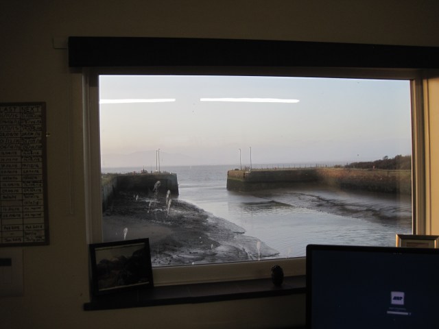
View from the Harbour Office window: Marshall Dock at low tide
You have probably never thought what it would be like to pilot a ship: to be in charge of, say, a cargo vessel with a hold-full of sticky molasses, that is about to enter the narrow dock gates of a port. But imagine yourself as the pilot: you have boarded the ship as it approaches its destination in order to explain to the captain how to manoeuvre his ship at this, the end, of his current voyage. You are responsible for the safety of a very large and expensive piece of kit which doesn’t belong to you. And if you’re piloting the vessel to the Port of Silloth, you also have a trip of about 90 minutes ahead of you before you reach the port near the inner end of the Solway Firth.
“Only the Victorians could have thought this was a good place to put a port,” Ed Deeley says of Silloth. “To put the entrance at 90 degrees to the main flow!”
Ed took on the job of Harbour Master in 2011, though he tells me that piloting ships has always been what he most enjoys; when we meet he has just returned from a piloting job at Ayr. Unlike Ayr, Silloth can only be reached via some of the most changeable channels and, on occasion, the largest Spring tides around the British coast. Any ship longer than 50 metres is required by law to wait off the Port of Workington to take on a pilot before it can head to Silloth. Timing is crucial because the port at Silloth is tidal – the depth of the water within the inner dock is maintained by lock gates – so the ship must arrive there just before high tide when the gates are open.


Despite the multiple layers of difficulty – the weather, the sea-state, the shifting channels, the time constraints, the angle of entry – Ed Deeley enjoys the challenge: “All these different factors – you’re trying to juggle them all!” Chris Puxley, the former Harbour Master and also a pilot, once told me that negotiating the entrance to Marshall Dock always provided “a gentle adrenalin rush”.


But the first job of a pilot is to board, and learn about, the ship. The pilot boat Derwent takes him out from Workington to the waiting ship, where he goes straight up to the bridge to meet the Master. Both Chris Puxley and former pilot Bill Amyes have previously told me stories about their experiences in The ship’s pilot’s story , but I was keen to meet Ed and get an update on piloting and the port itself.
Unlike many Harbour Masters, Ed dresses informally, no blazer or peaked cap, and he doesn’t like to be referred to as ‘Captain Deeley’; he smilingly hints that some of the Masters might find this a little unusual. Despite this, he needs to find out about the ship (“The captain knows his ship, we don’t”), and there’s an important check list to complete: the stability of the ship, the types of equipment, whether the anchors are free (“sometimes they’re cemented in place and you don’t want to be hammering at them to get them free if you really need them”). And there is the Passage Plan: the pilot discusses the course with the captain, and explains, with the use of diagrams, what will happen when they reach Silloth.


Then, they are ready for the journey up the Firth, keeping to the ‘English Channel’ amongst the sandbanks and the ‘Changeable Depths’. From an aerial point of view of the Firth during the low water of a ‘big’ Spring tide, it’s obvious why a pilot is necessary – and why frequent bathymetric surveys need to be carried out on the channel: rocky scaurs project out into the Firth, and the whale-backs of sandbanks are pale against the glistening sea.
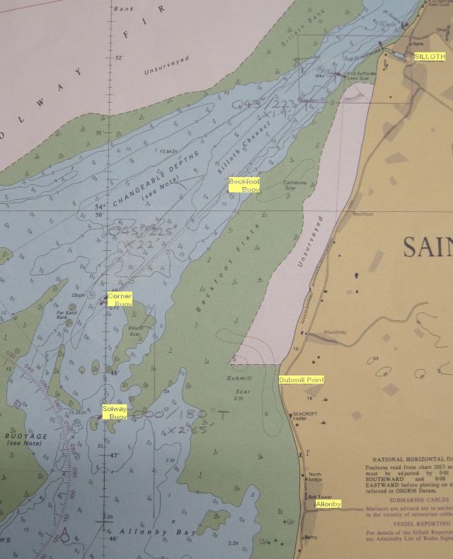
Detail of Admiralty Chart to show the three buoys that mark the channel (note ‘Changeable Depths’). Photo: Ann Lingard
At the North end of Allonby Bay the course is marked by buoys. “Between Solway Buoy [off Dubmill Point] and Corner Buoy, it’s a critical region, the region that gives us the most trouble,” Ed tells me. “At Corner Buoy there’s a narrow corridor, that channel is our window – to the East of it are big boulders, the shrimp fishermen won’t go there, to the West are shifting sands. So we have to head North to North-West between the two sandbanks, then North-East towards the Beckfoot buoy.”
The ‘trouble’ is due to the shifting sands. “After the winter storms of 2014/15 we had it surveyed, and a lot of sand had moved around. The channel by Corner Buoy had been 3.8 metres deep and it had gone to just 1.3 metres deep. The sandbanks had spilled over. We need at least 1.3 metres by the Solway Buoy because there are boulders and rocks, so it was an awful situation.”
But interestingly, the survey, using multibeam sonar which is accurate enough to pick up details of sand-ripples, showed that for two or three cables (1) the bottom of the corridor – although less than half-a-kilometre wide – had remained unchanged.
“To the West were sharp sand-waves six to seven metres high, with channels or trenches between them,” Ed says, “but the bottom of the corridor looks smooth, it’s quite linear. They reckon the sand can’t take a hold.”
This is fascinating. We discuss whether this could be a peat-bank, like those sometimes exposed beneath the sand and shingle on the shore. Or a thick layer of boulder-clay or glacial till? Both those substrata are smooth and fairly stable. (For more recent information on the bathymetry and bottom of the channel, see ‘Seeing the Solway’s bottom’.)


(Photos of the tug Furness with thanks to John Forrester; there are many more relevant and interesting photos of Solway shipping on his website)
Every major storm sequence causes changes, and not only to the sea-bed and shore. In the winter of 2015/16, Beckfoot Buoy was swept away: in March 2016 three new buoys were lined up against a harbour wall, awaiting a tug from Barrow to tow them and their anchors, the IBCs (2) filled with concrete, out to their new positions.In September, the tug Furness did just that.
Not just the sea, but the rivers too
While attention is naturally concentrated on the effect of the storms on land, few people think of the effects on our ports and rivers – and the consequent enormous costs to the port authorities of the clean-up. The storms’ aftermath has seen enormous quantities of silt and débris such as tree-trunks brought down by the rivers, as well as dramatic changes to the profiles of the shores. At Silloth, sediment that builds up in the outer Dock, can be flushed out at low tide by opening sluices in the New Dock gates.


At Maryport, a specialist dredger, the BORR, was working throughout March, blasting the mudbanks with high-pressure water-jets, so that the stirred-up sediment was carried out with the tide. At Workington, two different types of dredger have worked at the mouth of the River Derwent and in the port’s turning basin for almost two months, scooping or sucking up the sediment and carrying it out to sea. Their activities have been followed by Danny Ferris and John Forrester, whose websites Solway Shipping and Cumbria Ship Photos, respectively, provide valuable insights into the workings of the West Cumbrian ports.
Entering Silloth docks

")
The entrance to Marshall Dock is at right-angles to the tidal flow: difficult at any tide but especially so when the biggest Spring tides – potentially 9-10 metres at high water – are running. Entry must be at high water when the tidal flow is at its minimum, but “there’s no slack water at Silloth”, Ed says. “There’s a counter-current, especially on the big tides, just off the port entrance – it rips in the opposite direction. And there’s a ‘top run’ where it ebbs earlier at the entrance.” Pencilled diagrams on Ed’s Passage Plans give graphic explanations of the ship’s potential movements.


(The Baltic Sailor, piloted by John Munro, on a blustery day in August 2016)
‘We stop the ship three cables off the entrance and wait for the tide to drop off, then I’m aiming at West Beach, crabbing in – the counter-current off the entrance is pushing the stern in the opposite direction even as the bow is inside the dock.”
Entering the dock presents different problems, too. “When you enter a narrow channel, there’s a hydraulic effect, the water speeds up under the ship. It’s asymmetrical and unbalances the ship. Then you enter New Dock, which is the shallowest point and the hydraulic effect increases. The flow underneath causes the ship to ‘squat’ – it sits lower in the water, it becomes deeper.”
New Dock isn’t huge, and there may be other vessels there already, ranging from scallop-boats and trawlers to cargo vessels, taking up space along the quays.


“We get into the dock and then we have to turn the ship. The captain needs to tell us how the ship behaves when going astern – it’s an effect of the propellors – whether the ship tends to swing port or starboard.” Tricky enough on a calm day, but even harder when there’s a strong wind and the space is limited. Tricky at night, when the two onshore leading lights must be lined up for the correct angle to approach the gates (see Master’s Passage Plan diagram above). And even trickier when the vessel being piloted is the Zapadnyy.
If you are now realising a little of what piloting a ship entails, enjoy considering the Zapadnyy. This cargo vessel carries molasses, for use in animal feed; molasses presents a special problem because it must not be allowed to get too cold or too warm. I first heard about her in connection with some emergency welding that had to be carried out on the dock, and all the pilots have stories to tell about her. “She’s unmanoeuvrable!” (Bill Amyes); “It’s anybody’s guess which way she’s going to go” (Ed Deeley); “She’s got such a broad beam. It’s like trying to steer a coracle” (Chris Puxley). There is a short video of Zapadnyy entering Silloth’s Marshall dock here.
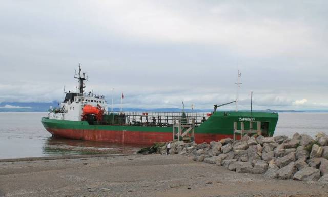
The day the Zapadnyy got it wrong. September 13th 2016. Photo thanks to Danny Ferris
(See more of Danny Ferris’s striking photos on his Solway Shipping website)
But Ed also adds, “She’s a Bulgarian bunker barge. She’s got a very competent bridge team as well as a very good echo-sounder! And she’s the only vessel that manages to keep molasses in a good state.”
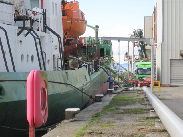
The Zapadnyy, unloading warm molasses through a pipe (photo: Ann Lingard)
(1) A cable length is 180m
(2) IBS: Intermediate Bulk Container
